
-
 Open your account online within 24 hours
 -
 Nationwide, next day delivery available
 -
 Over 200 locations near you
3D Laser Scanning
Laser Scanning is an increasingly popular tool for collecting vast amounts of accurate spatial data within a short amount of time. This makes laser scanners a popular piece of equipment within surveying, film and archaeology companies where on-site time may be restricted. Mobile Mapping equipment uses laser scanning technology to capture Survey Grade 3D point clouds and calibrated 360° imagery while travelling. Mobile mapping allows land surveyors to survey roads and difficult to reach areas quickly and without interrupting day-to-day life. These devices can be mounted to vehicles and are available as backpacks or as handheld devices.
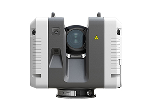
Laser Scanners
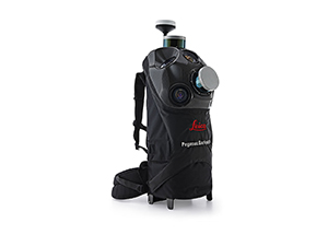
Mobile Mapping
Text placeholder